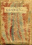
Bowles's Reduced New Pocket Plan Of The Cities Of London And Westminster
With The Borough Of Southwark, Exhibiting The New Buildings To The Year 1775.
~ Click Here To View The Map Image Without Borders ~
The Map
| Map Title: |
Bowles's Reduced New Pocket Plan Of The Cities Of London And Westminster, With The Borough Of Southwark, Exhibiting The New Buildings To The Year 1775. |
|
| Slipcase Label: |
A New Plan Of London 1777.
Printed For Carington Bowles in St Pauls Church Yard.
|
| Mapmaker: |
Carington Bowles
|
| Publisher: |
Printed for Carington Bowles, at his Map and Print-Warehouse, No. 69 in St Paulís Church Yard, London.
|
| Engraver: |
Engraved by J. Ellis, Clerkenwell, London. |
| Date: |
Published as the Act directs, 30 March, 1773 |
| Date of Map: |
Updated to 1775 |
| Size: |
39.3cm x 55cm (15½" x 21¾") |
| Scale: |
4" : 1 mile |
| Extent: |
Islington - Shadwell - Newington Butts - Knightsbridge |
| Description: |
Scale & compass rose bottom right. Imprint & table of references to churches and principal buildings located below map. |
|
Map divided into squares lettered along margins for reference. Built-up areas stippled in city, hatched elsewhere ( Howgego pp 126).
This is a 1775 map in a later 1777 slipcase. This copy is an earlier state than the first known copy recorded in Howgego as No. 168 (1). |
Click here to view the TABLE of REFERENCES to the CHURCHES and PRINCIPAL BUILDINGS, shewing their situation in the above PLAN.
This table is a comprehensive list of churches and principal & public buildings shown on the map. Each building is labelled with a number or letter, with a grid reference to aid with location and identification. The grid references are of no value to the digital representation of the map displayed here, but have been transcribed from the table for posterity.
The table instructions read:
A TABLE of REFERENCES to the CHURCHES and PRINCIPAL BUILDINGS, shewing their situation in the above PLAN.
The PLAN is divided on the four Sides into Miles and half Miles: And for the easier finding the Buildings referred to in the above Table, every Division of half a Mile, at the Top and Bottom of the PLAN, is marked with a Capital letter of the Alphabet from A to K: and on the Sides with small letters from l to q.
Suppose you want to look for the Royal Exchange; the Table shews that e in the Plan is the Reference thereto, that it is situated in Cornhill, and is to be found in the Square formed by the extreme Lines of G and n.
Each building number and name (ie. (6) Allhallowís London Wall) from the table of references has been included among the street names displayed on the individual map section pages. The search engine below replaces the need for a grid based reference to the buildings.
Please note that (e) Marlborough House, St James's Park, has not actually been labelled on the map. It is situated directly to the east of St James's Palace. This is the only building label missing from the map.
How To Use These Map Pages
Use the thumbnail map at the top of each page to navigate your way around the map.
Hovering your mouse pointer over the thumbnails will display a pop-up message showing the areas covered by that map section. Click the desired area to jump to a page displaying a full size image of that map section. You will need to scroll down the page a little to see the image of the map section.
A coloured thumbnail image on the thumbnail map shows you which section of the entire map you are currently viewing.
Place Name Search Feature
This map includes a comprehensive search feature for place names. The search feature is located at the top right of each page, with a search box containing the words "Search This Map". The Search Engine enables a targeted search of the entire 1775 map of London.
The spelling of place names has been accurately transcribed from the map, and reflects the spelling used in 1775. No modern updating of street names has been applied, so some lateral thinking may be required to find a desired street or place.
You can start your search of the 1775 map of London here:
Please note that this is not a general search engine for the entire MAPCO website, but is targeted specifically at the map currently being viewed. The entire MAPCO site can be searched using the Google Search Engine on the Search Help page.
The Search Engine has also compiled a Complete Index Of London Street & Place Names from the 1775 map of London, which is well worth referring to.
London 1775 Place Names Transcription Project
Transcription of the place names from the 1775 map of London was generously carried out by a team of eager volunteers. I owe a debt of gratitude to all involved for their enormous efforts in making this such a success, enabling the implementation of the Search Engine for this map.
My sincere thanks go to the following transcribers for all of their help:
Sally Brady
Jim Clay
Jane Knipe
Richard Rowe
Dave Stokes
Thank you!
Take a look at the Place Names Transcription Project page to see how the project was carried out.
|


