Map Of North West Kent 1789
Taken From
The Country Twenty-Five Miles Round London Planned From A Scale Of One Mile To An Inch
By William Faden
~ Click Here To View The Map Image Without Borders ~
The Map
| Map Title: |
The Country Twenty-Five Miles Round London Planned From A Scale Of One Mile To An Inch. |
|
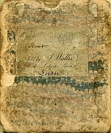
| Slipcase Label: |
Kent. Sold By J. Wallis, No. 16 Ludgate Street, London. |
| Mapmaker: |
William Faden.
|
| Publisher: |
Published January 1st 1789 by Wm Faden, Charing Cross.
|
| Date: |
1 January 1789. |
| Size: |
51cm x 61cm (20" x 24") |
| Scale: |
1" : 1 statute mile |
| Extent: |
SE London - Mucking/Tilbury - Yalding/Tunbridge - Godstone/Bletchingley |
| Description: |
Hand-coloured map of South East London & North West Kent; South East quarter of map only.
Recorded as Howgego No. 188 (2)
A note in the bottom margin reads:
EXPLANATION The Scale round the Map is divided into Statute Miles East & West from the Meridian of London; and North & South from the Parallel of the same place, which is in Lat. 51°.30". The Turnpike Roads are all laid down from an actual Measurement with a Perambulator.
This is a wonderful companion map to Captain William Mudge's An Entirely New & Accurate Survey Of The County Of Kent, With Part Of The County Of Essex 1801. |
How To Use These Map Pages
Use the thumbnail map at the top of each page to navigate your way around the map.
Hovering your mouse pointer over the thumbnails will display a pop-up message showing the areas covered by that map section. Click the desired area to jump to a page displaying a full size image of that map section. You will need to scroll down the page a little to see the image of the map section.
A coloured thumbnail image on the thumbnail map shows you which section of the entire map you are currently viewing.
Place Name Search Feature
This map includes a comprehensive search feature for place names. The search feature is located at the top right of each page, with a search box containing the words "Search This Map". The Search Engine will enable a targeted search of the entire 1789 map of North West Kent.
You can search the transcribed sections of the map of the North West Kent here:
Please note that is not a general search engine for the entire MAPCO website, but is targeted specifically at the map currently being viewed. The entire MAPCO site can be searched using the Google Search Engine on the Search Help page.
Place Name Spelling
The spelling of place names on this map has been transcribed exactly as it is recorded on the 1789 map. As such, please be aware of the contemporary 1780s spelling idiosyncrasies when searching for place names. A few examples of this are shown here:
| |
Modern Spelling |
As Recorded On The 1789 Map |
| |
Bayley's Hill |
Baylis Hill |
| |
Chislehurst |
Chesilhurst |
| |
Coldharbour |
Cole Harbour |
| |
Fish Hall |
Fishall |
| |
Hollanden |
Holland Den |
| |
Oxon Heath |
Oxenhoath Mill |
| |
The Postern |
Paston Haugh |
| |
Sevenoaks Common |
Sevensak Common |
| |
Shipbourne |
Shipborne |
| |
Tonbridge |
Tunbridge |
| |
Underriver |
Great Under River |
The more obvious of these errors (such as Chesilhurst) probably occurred because of the map makers' lack of familiarity with local place names, coupled with the difference in local area accents, resulting in the inaccurate recording of some of these places. This was a common problem for map makers, and many examples of this can be found on maps displayed on the MAPCO website.
The Search Engine has compiled a Complete Index Of North West Kent Place Names. If you cannot find the place you are looking for using familir spelling, try searching for it in this alphabetical list of place names from the 1789 map. This, for instance, would be the only way of finding Chislehurst on the map.
Kent Place Names Transcription Project
Transcription of the place names from the 1789 map of North West Kent was generously carried out by a team of volunteers. I owe a debt of gratitude to all involved for their enormous efforts in making this such a success, enabling the implementation of the Search Engine for this map.
My sincere thanks go to the following transcribers for all of their help:
Ross Bannister
Barbara Brenchley
Colin Harl
John Hartley
Jo Mason
John Orchard
Ray Risely
Martin Samson
Dave Stokes
Alan Thomas
Thank you!
Take a look at the Place Names Transcription Project page to see how the project was carried out.
| 


